
Hi, I’m Kevin, and I would like to share my knowledge of some of the best hiking you can do within an hour and a half of Valencia.
I am from England and have lived in Valencia for 12 years. I love exploring the trails around the Valencia region. There is much on offer, from mountain routes to coastal ones. In the summer months, there are lots of opportunities to swim in the rivers and natural pools on these hikes. And in the winter months, you may get the trail all to yourself!
Here are some of my favorite routes in order of level of difficulty.
If you don’t want to drive or are unsure of finding the correct routes, you could choose one of my private guided tours. Check them out at differentvalencia.com.

La Devesa de l’Albufera
- 💪 Difficulty: Easy
- 🚙 Distance from Valencia: 15 minutes
- 📏 Hike Length: 2-3 km
This is the easiest and closest hike to Valencia. It starts by the car park of Albufera Lake just south of Valencia.
Albufera is Spain’s largest lake and supplies the water for the irrigation system to grow the paella rice in the surrounding fields.
Fun fact: Several hundred years ago, the lake actually used to be 10 times larger. It extended as far as Ruzafa in Valencia! Just imagine all that vast area of flat land used for farming the rice covered in water.
Check the lake out before your hike by going to the viewpoint with the wooden jetties just from the entrance to the car park on the main road. Then head back to the car park and find the trail leading towards the sea on the left side.
The trail passes through the forested natural park of Albufera.
You will come to a small lake just meters from the shoreline but separated by high sand dunes. It looks natural but is artificial. It was made in the 1960s when the council planned to build a port with living flats like Port Saplaya, north of the city. Thankfully, it did not materialize, so the beautiful nature reserve remains.
If you want to bring a picnic, there are shaded areas around the lake. You can walk around the lake too. A sand dune path connects the lake to a nice beach. The beaches just south of Valencia by El Saler are better than the beaches to the north of the city.

Top Tips
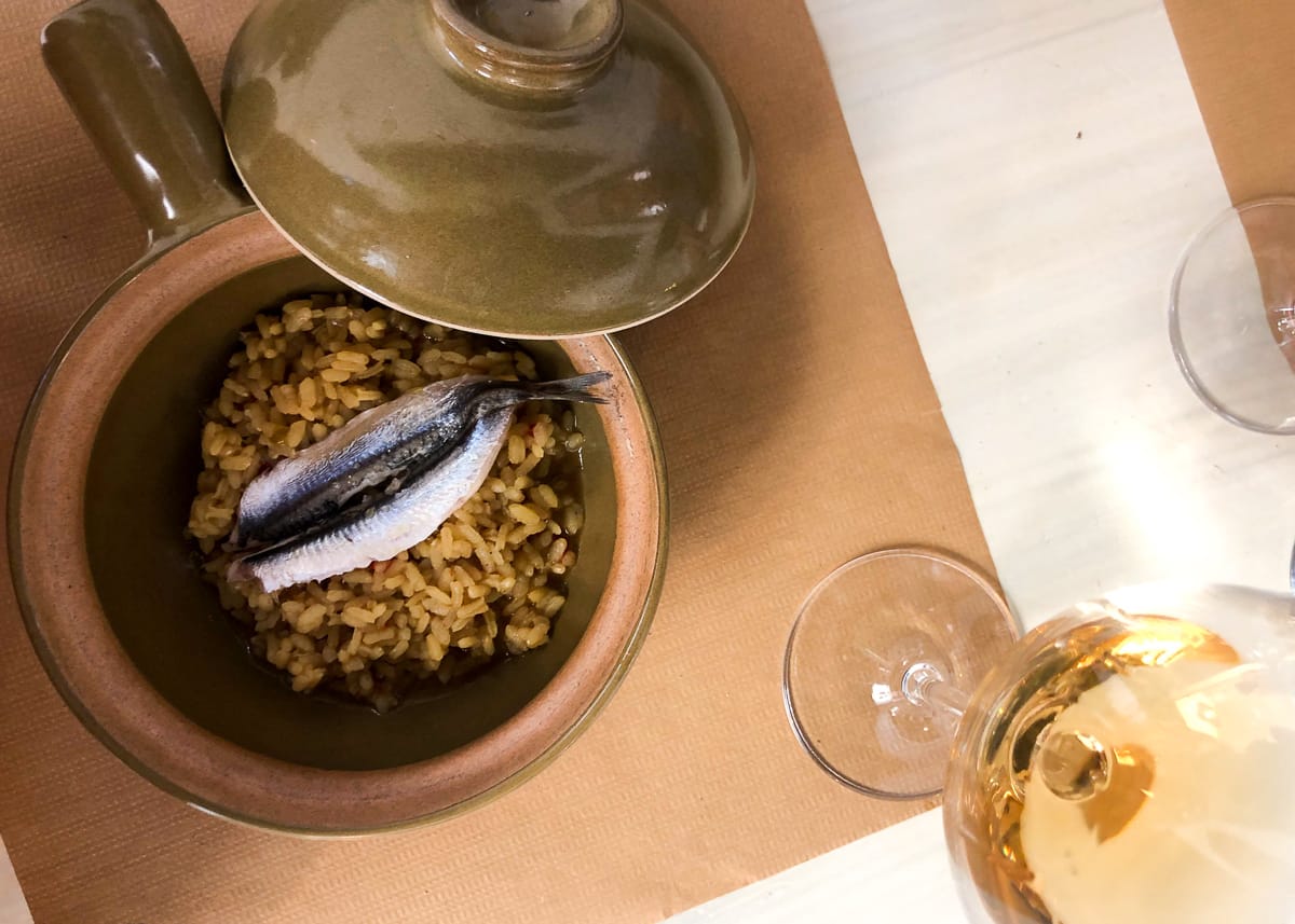
- Why not combine your walk with a paella lunch in El Palmar? The village is just 10 minutes’ drive from La Devesa. Rather than an actual village, it is several streets of paella restaurants, literally the home of paella. Make sure to book in advance.
- Rather than drive, you can hire a bike and cycle there. Bike lanes go from Valencia, past Pinedo and El Saler and connect onto La Devesa through the nature reserve forest trail.

Los Acantilados de Benitatxell
- 💪 Difficulty: Easy
- 🚙 Distance from Valencia: 90 minutes
- 📏 Hike Length: 4 km
Situated between Jávea and Calpe, is the amazing coastal cliff walking route by Benitatxell. The trail is situated between two pristine beaches.
You can park in the large lot by Cala Moraig. A "cala" is a rocky/pebble beach surrounded by cliffs. This beach has brilliant turquoise water and an interesting cave formation called Les Arcs, which you can walk into.
The walking route is 80m above the sea, actually within the cliffs. It affords fantastic views of the Mediterranean. There are various old stone huts along the route, which have been used in the past by fishermen or smugglers. The path is wide and perfectly safe.
It leads to a quiet beach called Cala Llebeig. This beach can only be accessed by walking trails, so it is more secluded. Here you can swim, relax and sunbathe and explore the old fishing huts.

If You Go Between June and September:
These are months when people choose to swim in the sea (unless you like it on the cold side). That’s great because you can snorkel and see some fish.
But in July and August, be warned. The beaches on that coast get very busy as everyone migrates to the water to escape the heat, particularly on the weekend or any day in August.
Be prepared to park on the road much higher up the cliff, as spaces will be taken by late morning. You will have a steep walk down and up along the pavement.
Top Tip:
- If you decide to go in July or August, be prepared for a very hot hike. Go in the afternoon and take a picnic. Swim on the first beach and do the cliff walk wet, then stay on the second beach until evening. Then have a sunset cliff walk back to the car when the temperature has dropped and the colors are reflecting off the sea.
If You Go Between October and May:
You could still swim up until mid-October or from the middle of May on a warm day. It depends on the person.
The big advantage is the walk can be done in cooler temperatures and there are far fewer people. If you go from December toMarch, you may well be the only one on those beaches, which adds an extra wow factor.

Top Tips:
- Check out the scenic viewpoint in the area called el Cabo Negre, which is a 20-minute drive away from Cala Moraig.
- Drive to another very scenic beach called La Granadella. This beach gets voted the most beautiful beach in Spain. But avoid in July-August due to it being overly crowded.

Montanejos and the Thermal Springs
- 💪 Difficulty: Medium
- 🚙 Distance from Valencia: 80 minutes
- 📏 Hike Length: 9 km, 3.5hr, circular, 400m elevation.
Easier Alternatives
You can consider hiking the family trail ("ruta familiar") instead. It is 5 kilometers (2 hours) and suitable for kids from seven years old and up. Just ask at the tourist center.
Or skip the hike entirely and head straight to the thermal springs.
The village of Montanejos and the surrounding mountains are beautiful indeed, covered with pine forests, vegetation, and the fresh air those provide.
There are many hiking trails around Montanejos but the most spectacular is the 9-kilometer trail which follows the river Maimona and its impressive canyon. It is called the route of La Bojera.
Best would be to park in the village or just outside by the petrol station as you approach. Have a coffee in one of the village bars and visit the tourist information center to get a hiking map and ask any questions about the route.
The entrance to the trail starts just next to the petrol station. If you go in the weekend in summer season and parking is difficult, you can actually drive up the entrance to the trail which looks like it is just for walkers. It takes you above the petrol station, where you can park your car.
Make sure to look at the signpost at the start of the trail by the main road, which will tell you the color coding for your route. Rocks and trees are painted along the way to guide you at points where the route deviates. These are made easy to follow with the intention of helping first-timers.
The trail starts quite steep, getting you above the village with great views. The canyon is a highlight, which you pass along. Then you descend through forest to the bottom of the valley. You cross the small river/stream of Maimona on stepping stones, then ascend again through forest back towards Montanejos village.

The Springs
The thermal springs of Montanejos maintain a constant temperature of 25°C all year round. You can relax by sunbathing on the shore and taking a swim in the crystal waters.
You can choose to have lunch in one of the local village tapas restaurants (recommended!) before the springs or take your picnic with you. The best part of the springs is across the high bridge and along the path down to the river. Walk about 8 minutes up the river to where the large pools are. There are toilets, changing rooms, and a kiosk there in the summer months.
If you swim around the bend of the lagoon you will find a deeper part past the overhanging trees. Then you will walk again through shallow water. Just past this, there is a deeper pool where you can jump off a 3m rock into the lagoon. Nice.
Top Tips:
- Like any natural watering hole in southern Spain that you can swim in, it gets very busy in July and August. Be prepared for a lot of people on the weekend and any day in August. In fact, you will need to buy an entrance ticket (3 euros each) to the springs for July and August, which controls the number of people allowed in. Best to buy online, but you can also buy at the entrance on the day.
- Bring some water shoes if possible, for the springs have small pebbles.
- Avoid the La Bojera hike from June 15 to September 15 unless you like it HOT! Or arrive there very early, like 8.30am. If it’s very hot, choose the family trail instead. It is nearly all covered by pine forest. The good thing is the area is inland and 700-1,200 meters above sea level, so it is a little cooler and less humid than Valencia.
Ideal Timings
- 9:00 – Leave Valencia.
- 10:20 – Arrive at Montanejos. Take a coffee and get a map from the tourist info.
- 11:00 – Start the trail.
- 14:30 – Return to Montanejos and head to a restaurant for lunch (book ahead).
- 16:00 – Head to the thermal springs.

Extra Cool Things to See:
After the springs, head back to the car and drive only a few minutes up the mountain road, passing through two tunnels. Just after exiting the second tunnel, there is an area to park. Walk down the path for a few minutes and find something quite unusual:
A massive horizontal water jet (El Chorro) made from the Arenoso dam.
Cool down with the water spray and take some cool photos. Then drive up the road for a minute to the dam and have some great views of the reservoir in the early evening before returning home.
The Best Months to Go
September, October, November, April, and May are not too hot for the hike and not busy at the springs.
You can still swim in the thermal springs in the winter months as they are 25°C all year round, but bring a warm top and coat to warm up afterward. The reward is you may have the springs all to yourself!

Chulilla Canyon Trail
- 💪 Difficulty: Medium
- 🚙 Distance from Valencia: 50 minutes
- 📏 Hike Length: 17 km, 4.5hr, circular.
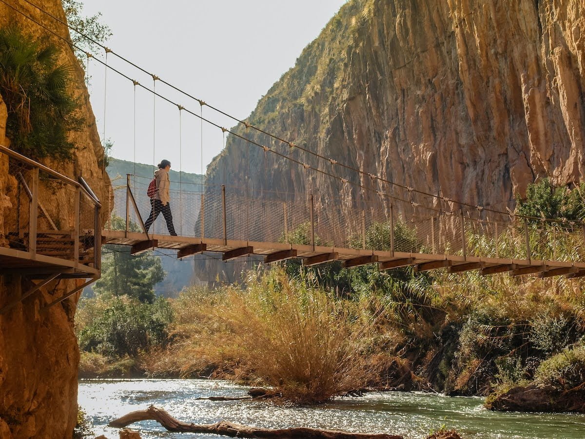
The route has an inspiring combination of gorges, valleys, vertical cliffs created by the Turia river, hanging bridges, forest, green vegetation, a reservoir, and the blue lake.
It really is a unique route and considered special in the Valencian region. The hike finishes at the beautiful village of Chulilla.
You can park in the designated car park at the end of the village past the main square (small parking fee at busy times of the year). If full, park on the roadside leading up from the lot or in one of the off-road parking areas.
Walk into the village and head to the central square. Have a coffee before the hike in one of the bars.
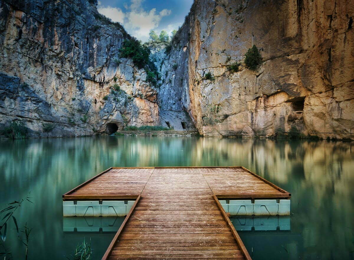
Find the sign post leading to the Charco Azul (blue puddle) in the main square. Follow it down the valley and follow the river Turia upstream until you arrive at the Charco Azul which is about 20 minutes from the village. There is a newly constructed jetty which you can walk on to get some great photos.
Then walk back the way you came, following the river. This time, do not go back up to the village but continue the path around the hill and castle. Continue along the path away from the village, crossing the river and up into the hills. With this route, whenever you have a choice of left or right, always choose the right option, going in a circular fashion. The way is also marked by paint lines at these forks.
Be sure to look out for the sign indicating some 5000-year-old cave paintings about 40 mins after passing the village. The paintings are quite hidden in the rocks. To find the wooden steps that take you up to them, look for a little collection of mounted stones and pebbles someone has made to indicate their location.
After several more kilometers, you will begin to see the reservoir Loriguilla in the distance as you walk closer to it. When you reach the reservoir, take the road path towards the canyon.
You will then have several kilometers of spectacular canyon trail with interesting vegetation along the river. You will cross two hanging bridges, one 5 meters and the other 15 meters above the river. Then it takes 30 minutes to walk back to the village.
Fun fact: The hanging bridges are replicas of the original hanging bridges, which were constructed in the 1950s to allow access for the workers to build the dam. In 1957 those bridges got washed away when the dam burst in the great flood which ravaged Valencia and led to the decision taken to divert the river around the city. The new bridges were only rebuilt in 2013 to promote tourism in the area. An excellent idea indeed, as the canyon trail route was not possible before.
In the village, you can stop for a feel-good beer in a bar after the hike. If you have any energy left, you can walk up to the castle ruins, which sit above the village. It was occupied by the Romans and then the Moors. Or, if you started the hike early enough, you could have lunch in one of the restaurants.
Easier Alternative
The circular hike is only suitable for a minimum of 12 years. A shorter kid-friendly hike can be chosen instead—minimum age of 8 years.
From the village, head the other direction toward the hanging bridges. Five minutes minutes up the road from the village car park, there is a sign on the left side where the trail starts. Go to the bridges then come back (1.5 hours). If you want, then go down to the Charco Azul from the main square (20 minutes each way).

Top Tips:
- Do not do the long circular route in July and August. It will be too hot and there is not enough shade cover. But if you still want to do it, make sure you start the trail no later than 8:30. The cooler months are ideal for this route. It can get busy at the weekend on the hanging bridges canyon part in October, March, April, and May. Take plenty of water.
- You can take a picnic. A good spot for lunch is the valley of rocks where the cave paintings are.
- Book restaurants well ahead for weekends in busy months.
Ideal Timings
- 8:30 – Depart Valencia.
- 9:20 – Arrive at Chulilla and have a coffee.
- 10:10 – Start hiking.
- 14:45 – Return to the village in time for lunch. This is not late for Spanish people. Book ahead. Also note that lots of restaurants are closed mid-week.

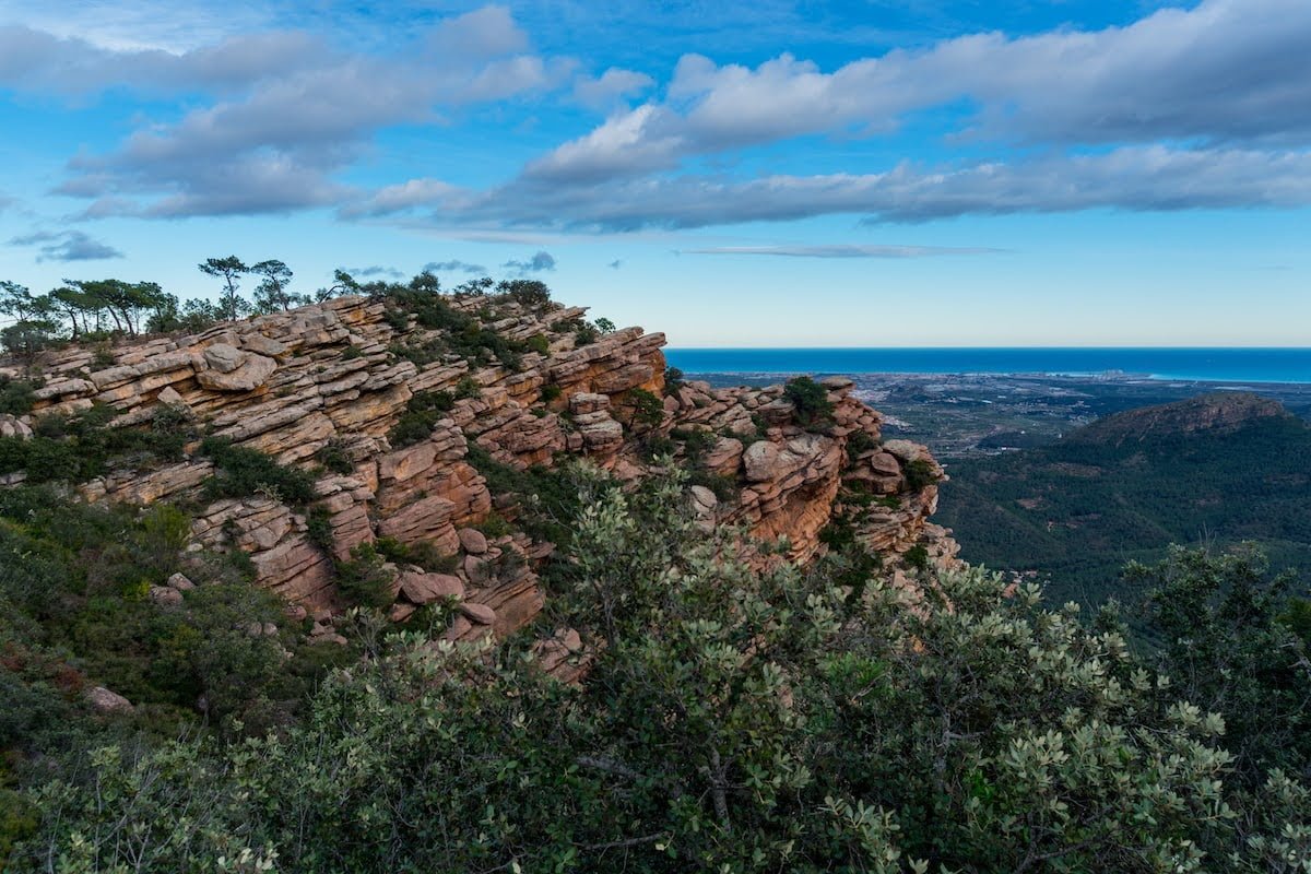
The ‘Chains’ Route Up to El Garbí (Ruta de la Cadenas/Canal del Garbí)
- 💪 Difficulty: Medium Hard
- 🚙 Distance from Valencia: 35 minutes
- 📏 Hike Length: 8 km, circular, 3hr, 500m elevation.

This one is a lot fun and very rewarding with the spectacular views over the region.
It is classified as hard because it is very steep, taking you up a cliff. Some parts have chains attached to the rock to help you up. Saying that, you do not have to be a serious climber. Anyone who is in reasonable fitness can do it. I have seen families take their young teenage kids up, so don’t be intimidated.
Park by the village Segart and walk back down the road for a few minutes until you see the sign on the left-hand side indicating the start of the route. It will be signed "Ruta de la Cadenas" or "Canal del Garbí." The ascent will be marked with red and white paint lines on the rocks.
Once at the top, walk along the cliff top toward the famous lookout called El Garbí. There is also a car park if you want to drive there without the hike, which most people do. From here, 600 meters above sea level, you can see Valencia, Sagunto and its castle, the Mediterranean and on a clear day the Albufera lake behind the city.
Heading back down is rather tricky, so I recommend the path, which is the GR10 to Segart por la Pedrera. You will find this sign if you walk along the top of the cliff where you climbed up but in the other direction to the viewpoint. Using an online map route would help with this. It is a 1-hour descent (3km) back to your car.
Top Tip:
- If you want to eat a traditional paella in a mountain restaurant, try El Chapparal. They cook their paellas on traditional open fires and have a lovely terrace surrounded by pine forest. Book early, as it is always popular. Also, it is only open at the weekend. Try their specialty drink called "cremaet": coffee with brandy, cinnamon, and citrus spice.

Happy Hiking!
These routes have been tried and tested by Kevin Lane, the owner of the day tours company differentvalencia.com. Reach out to him with any questions about these or other hikes around Valencia.