An Out of this World Hike…so Close to Medellin!
This post is part of Everything to Know Before Visiting Medellin, a collection of no-B.S., unique guides to an unforgettable stay in Colombia.
One-way hikes are the best. Jungle waterfalls are awesome too. So are magnificent views. And this hike, which goes from Pablo Escobar’s old “prison,” La Catedral, down through pine forest, jungle, two waterfalls, and ending with an amazing view, has it all. It's fantastic.
Even better? It’s just minutes away from the city of Envigado (and Medellin).
Here's everything you need to know.
Quick Info
- Difficulty level: The distance is not far and it’s almost all downhill, with an elevation loss of about 300 meters. The challenge is climbing down a few very steep slopes, walking through rivers, and jumping from rock to rock.
- Signage: Not great. Expect to get lost. But don’t expect to not find your way eventually. Follow the instructions and maps below along with your long-lost ancestral, hunter/gatherer intuition.
- Distance: Approximately 4 km / 2.5 miles
- Elevation: Descent of about 300 m / 1,000 ft total.
- Duration: 1.5 to 5 hours. We took two hours with quite a bit of lollygagging to get from la Catedral down to the Arenales viewpoint and bus stop. If you go fast you could do it in an hour and a half. You may also need much more—Multiple readers including Kat and Heather shared in the comments that her group took five hours, in part because the descent to Salto del Angel was tricky.
- What to Bring: Water shoes or a bag to hold your shoes while walking along the river barefoot. Bathing suit. Warm layer. Snacks, water, and the usual hiking gear.
Map
Download this map to your phone (here are quick instructions for using Google Maps offline), and use these waypoints to guide you if (when) you get lost walking through woods, jungle, and rivers.
Better yet, here's the route on Wikiloc. (Note that the person who mapped the route did it in the opposite direction that we recommend.) To follow this route on your phone and be certain not to get as lost as we did, download the Wikiloc app, and pay just $2.99 USD for a 3-month subscription.
Getting to the Hike
Take the metro to Envigado station (or the bus along avenida El Poblado if coming from Poblado). From there, the only buses that go all the way to La Catedral leave at 5:45 a.m. and 3 p.m. so take a taxi.
Don’t be off-put when taxi drivers tell you it’s a fixed rate. It’s true. Most Envigado taxis even have the fixed fare posted on the passenger side sun visor, right next to the fixed rate for the airport. It should cost either 25,000 or 35,000 COP (we’ve seen both) for the 20-30 minute ride up the mountain.
The ride itself is quite the experience. Your taxi will put its engine to the test to carry you way up out of city and into the lush farms and hillside.
Hike Guide
1. La Catedral
As any viewer of Narcos will know, La Catedral was an extravagant prison Pablo Escobar agreed to incarcerate himself in with all his buddies, while still running his business and having big parties.
Now it's an old-folks home.
Most of La Catedral has been destroyed and, frankly, it's not particularly interesting, though there are some guard towers still standing that comically have mannequins dressed as prison guards inside them.
That's not to say it's not worth checking out. I was surprised by just how close La Catedral was to the city, and I could still sense the aura of what it must have been like in the early 1990's when the world's most notorious criminal was running his cartel from the very ground I was standing on.
And while there is a decent view of the city, don’t waste all your megabytes on it. An even nicer view of Medellin awaits at the end of this hike.
2. La Catedral to Salto del Angel Waterfall
Time to start hiking!
Look around La Catedral and you will find signs guiding you towards the path to the Salto del Angel. This first part is well-marked.
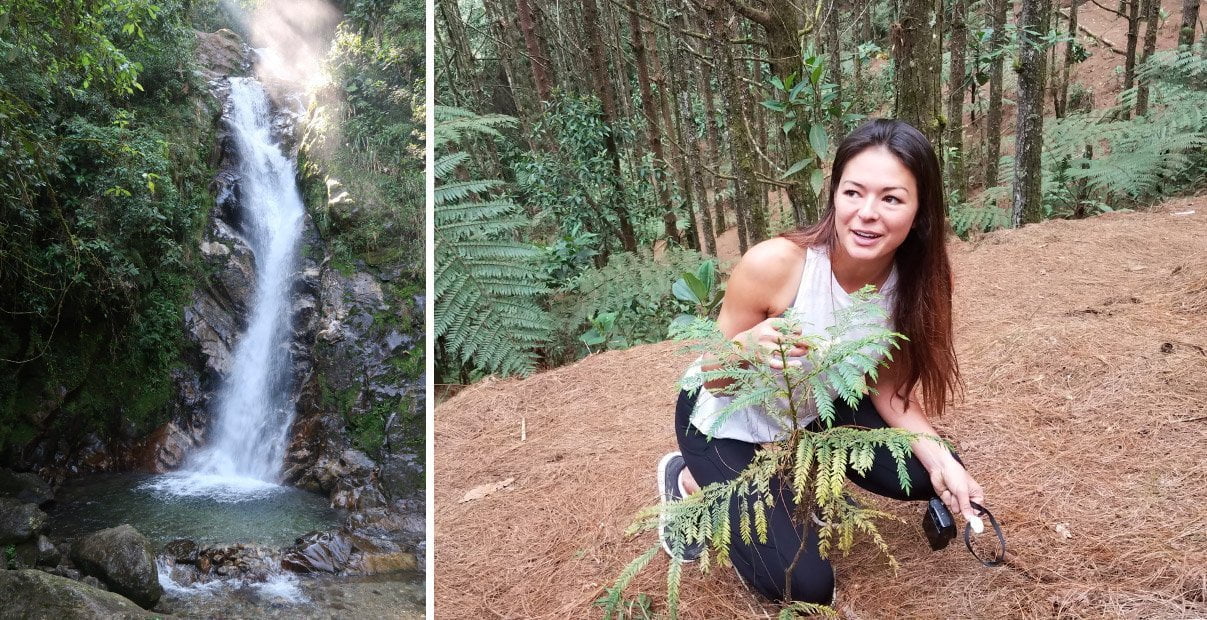
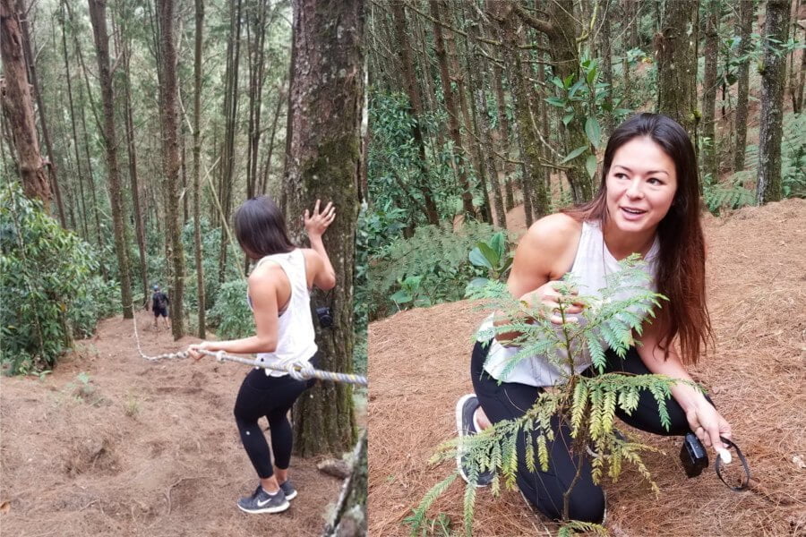
Starting off in a pine forest, you will descend down some steep hills, often needing ropes to help you down, as in the picture shown here. Keep an eye out for flora and fauna, like this patch of edible hedgehog mushrooms we found.
In a blink of an eye, the pine forest transforms into tropical jungle and things get tricky. So tricky indeed that we missed the Salto del Angel when we went! That's why I highly, highly recommend you avoid our same mistake and use the Wikiloc map above.
3. Salto del Angel to Chorro de las Campanas Waterfall
From the Salto del Angel, the trail heads down alongside the stream, and sometimes across it. It's quite well established, but if in doubt, stick to the stream. As long as you do so, you can't get lost.
After about thirty minutes you'll arrive at the top of Chorro de las Campanas. Those who aren't afraid of heights and have steady feet can tiptoe down to peer over the edge down to the swimming hole below.
Unfortunately, the waterfall is much too high, and the pool too shallow, to jump. You will have to take the trail down. It is quite challenging. Our friend Paul, who joined us, slipped and got some nasty scratches on his back. Take your time and play it safe.
Once at the bottom, absorb its beauty, rest up, and go for a dip. The water is very fresh (a.k.a cold).
4. Chorro de las Campanas to Arenales Viewpoint
If you took your shoes off to take a dip below Chorro de las Campanas, keep them off! Either that or be prepared to get them completely soaked.
For the next 30-45 minutes, you'll be walking downstream, mostly in the stream. Even a ninja couldn't make it without getting their feet wet, so don't bother trying. It's faster and more back-to-nature in bare feet anyways.

When we last did this hike in late-January 2018, someone had recently spray-painted arrows to guide the way. Follow them, but note that the arrows are pointing towards Chorro de las Campanas waterfalls, so go in the opposite direction.
Your stream-walking adventure will be over once you reach a cement bridge. There you should put your shoes on and look out for kaleidoscopes of butterflies (who knew a group of butterflies is called a kaleidoscope?!). They congregate there for some reason.
From this point on the trail is uphill and easy to follow all the way back to the road. The intersection where you end up at, where there's a little shelter and a map of Arenales, is where the bus from Envigado comes and turns around. One comes every thirty minutes and costs 2,300 COP.
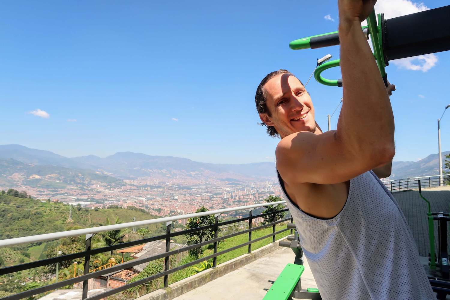
But before hopping on the bus, walk one hundred meters up to the impressive sports complex. There you will find a tremendous view of the entire city of Medellin.
It's also home to the most scenic workout area I've ever come across, so if you're feeling chipper why not do a couple pull-ups or squats?
5. Descend upon Your Next Adventure
If you've still got energy after the hike, consider paying a visit to the Finca La Leona Coffee Farm. It's half-way down the hill, right on the bus route. Kim and her family did the tour when I was out of town and quite enjoyed it. And as an added bonus source of interest, the owner, who you'll meet, is a French-Colombian who competed in the Olympics in speed walking!
Alternatively, Kat, who did the hike in September 2021 left the following suggestion in the comments:
"There's a family restaurant on the road out of the forest about 1km before the bus stop (coordinates 6.1332370, -75.5781883) – no name and nothing special in the food, but they were super kind to us, have a great view of the hills and part of Medellin, and the food/drinks were just what we needed to recharge!"
For those who are hungry, and I mean REALLY HUNGRY, you have to stop at La Gloria de Gloria— "Gloria's Glory" in English.
This restaurant is famous in Envigado and throughout Medellin and Antioquia for its forearm-sized portions of ribs and chicharron. Share one platter (bandeja) between 2 or 3 people. It's so impressive that it's both in our top 20 restaurants and top 10 things to do in Medellin.

Want More Medellin Adventures?
For more hikes like this in the Medellin area, our list of hike guides is your ultimate resource.
For all the ingredients you need to put together a magnificent Medellin trip—where to stay, what to do, what to eat, where else to visit in Colombia—see our Medellin Travel Manual.
And if you have any questions, comments, or suggestions to share with other readers, please share them in the comments!
I tried to sign up for the future hike posts but nothing happens when I click "submit"
Thanks for letting us know Anna. We've fixed the glitch and will let you know when we post about future hikes. See you out there on the mountain hopefully!
Great post. Thank you!
Thank you John for the kind comment. Hopefully you enjoyed the hike as much as we did.
So, after reading your post, we did the hike today.
It was definitely a challenge and we are glad we ran into someone who knew the way.
The trail to the first waterfall was well marked but everything after wasn't.
Plus, it took 5 hours, not the 2 that you described. We did take the ropes down to the Salto del Angel which added time because you also have to climb back up.
This is a very steep incline through out the hike and luckily there are ropes for some of it.
Use a guide so you don't get lost.
Thanks Heather for sharing your experience on the hike. Indeed a guide can be helpful for those who are nervous about getting lost. I've updated the post to include a map that future hikers can download and follow on their phone's GPS.
Hopefully, despite taking longer than expected you still enjoyed the hike!
Hi Chris, thanks for your post. I did the hike today and it went very well. It took about 2 hours as described, and overall it was pretty straightforward. However, I never would have been able to figure it out on my own without your post. Thanks!!
Hey Alex. Thanks to you for corroborating that it takes about 2 hrs and glad that we could help you follow the route. Hopefully you'll have the chance to explore even more hikes and adventures in Medellin.
My girlfriend and I are fairly avid hikers and found this hike more challenging than the article led on. No doubt it is absolutely stunning but you really need to put aside most of the day for this hike and make sure that no rain is forecast as the trails flood quickly and become very difficult to navigate.
Yeah, we only did the hike a couple of times, both of which were when the trail was dry. I could imagine it'd be significantly more difficult when everything's wet. And yeah, when you add in some time at La Catedral, chilling at the falls, transport, and waiting for the bus at the bottom, it'll definitely take the good part of your day to do. Thanks for the input, Alex!
Thank you for the super informative post, it really helped us with our hike! We appreciate it — especially the taxi advice! My husband and I followed this yesterday (April 2019) and recorded the whole trek from La Catedral to Santo del Angels to Chorro de las Campanas to the bus stop. The trek, in total, was 2.70 miles with a 400 foot ascent and 1500 foot descent. The bus is now 2.300 COP per person back to Envigado from Arenales. Also, at the Arenales bus stop, there was a small empanada and fruit stand which was very welcomed after the hike. Thanks so much, Kim and Chris!
I forgot to mention — we had a leisurely pace of swimming, snacking, etc. and the hike took 3-hours if people are wondering. Awesome hike, thanks again for clueing us in!
Super helpful comments, Ryan and Alex. We really appreciate it! Continue having a marvelous time in Medellin.
Hello, enjoyed your post as I was researching things to do on our upcoming tip. You do not offer guide tours or know of guide? I have been trying to look for a guide that will bring us on this same route you have documented, as I did not want to have to hike both up and down. 🙂 and have not had a lot of luck.
Hi Lori. Maybe try asking Kinkaj Hikes and Adventures? (See our Medellin hikes post for more info on them.) You can also just walk down one way from the Catedral, past the waterfalls, and to the bus stop, as we outlined here. Happy hiking!
I did this trail on your recommendation in November 2018. It was challenging, but amazing. I can't imagine trying to do this trail uphill. You'd need to be an Olympian.
WikiLoc didn't take me all the way to Salto del Angel, but that was OK. I settled for the nice view of it from the hillside.
The pine straw hillside was slippery but with the rope and trees to hang on to it was manageable.
The trail down to the bottom of Chorros de la Campanas is no joke! It's super steep, so you end up reaching from tree to tree. But watch out, some of those trees have really long needles. I grabbed a tree and took one of those needles right into my hand.
Make sure you bring some kind of water shoes or hiking sandals for the last part in the creek. I only had sneakers so I did the last part in the creek barefoot. It was OK, but it was slow going because the rocks in the creek are tough on the feet. I only fell once, though.
At Arenales, buy the fresh squeezed orange juice from the sweet ladies at the cart. It was delicious and they made sure to give me exact change for the bus home.
Happy 1-year hike anniversary, Dave! Thanks for stopping by to leave your tips. The orange juice sounds like the perfect post-hike pick-me-up. I'm glad you enjoyed the hike as much as we did.
Great hike indeed, thanks for sharing! We’re fairly fit and it took as 3 hours – that is including the Salto de Angel waterfall which was the toughest and muddiest part. What you didn’t mention is that Sato de Angel is a dead end, so it requires going the same way back (1 hour in total). At the end we took a bus at the viewpoint which goes all the way down to Envigado for 2.2k per person.
Amazing that there is such a beautiful hike this close to Medellín!
Sweet. Thanks Philipp for the info on Salto del Angel. I've added that note to the post for future hikers' info. Man do I wish I could do that hike today here in steamy hot Cape Town! Glad you enjoyed it.
Fantastic adventure!! Did this in March 2020 and it’s probably one of my favorite hikes given the waterfalls, microclimates (jungle, pine forests, etc), and varying terrain.
There are many steep slopes so expect to make use of the rope (where available) and tree roots. I recommend water shoes (not flip flops) for the hike from Chorro de las Campanas to Arenales Viewpoint as it would be rough barefoot
This hike took our party of 3 about 5 hours. We’re pretty fit (climbing, hiking) but much of the trail is technical and steep so tread carefully. And enjoy a beautiful day out!
One of the most beautiful hike we ever made. Thank you for the great explanation, it really helped us at times where there was no obvious path!!!
We saw everything and took about 4 hours from la catedral to arenales. We took our time at every waterfall and even took a dip in the very very cold water. But the surroundings were astonishing. So happy. Thank you.
Glad to hear the hike's still refreshingly beautiful 2.5 years after we've last done it. Thanks, Laurens!
My boyfriend and I did this hike yesterday (August 2021) and even though it is incredibly beautiful we agree with other commenters that this hike is more challenging and more time should be planned than described.
We included Santo del Angel which is VERY steep and challenging (at least 1 hour extra). And even though the beginning of the trail is marked, from Chorro de la Campana it's completely unmarked. We didn't have GPS and didn't know that we were at Chorro de la Campana (with the path we took we didn't arrive above but from below). We ended up getting lost around there shortly before sunset and ran the way back up to la Catedral.
We recommend starting the hike early enough to have time finding the path in case you get lost. Also during rain this hike wouldn't be recommendable at all. And get a good idea of the map and the waypoints (Chorro de Campana especially) so you know how to navigate without GPS.
Just did this trail today – definitely budget more time, and be careful if it's going to rain as there's lots of steep muddy bits.
They have put up official wooden signs along the entire trail, but the "official" way is still not always clear between Salto del Angel and Arenales – we had to do plenty of stream crossings. You can generally follow the stream if you get lost, but the official path often goes off to the sides, climbing up and back down to the water. Locals told us it takes 1hr from Salto del Angel to Chorro Las Campanas, and 1-1.5hrs from there to the bus stop. I think we cut some of that time by going directly along the stream as indicated by this article, but we followed some groups as well to make sure we weren't lost. All in all it did take us about 5 hours, with about 1hr of photo and swimming stops along the way.
There's a family restaurant on the road out of the forest about 1km before the bus stop (coordinates 6.1332370, -75.5781883) – no name and nothing special in the food, but they were super kind to us, have a great view of the hills and part of Medellin, and the food/drinks were just what we needed to recharge!
Thanks for the info, Kat. I've updated the post to mention it. Much appreciated!
Anyone do this hike with kiddos?
Hey guys. I get 22 ads shown (yes I took the time to count) on this article. It is disturbing. Maybe try to put less on Google ads and allow readers to enjoy the article. You lost me =(
Hey Chris. Sorry for all the distracting ads. I agree. I struggle to find better ways to earn back money for the time I put into this blog. I already make barely enough to support my family. I could stop entirely and thereby have no ads but no content either, or… what? Put up a paywall? I'm open to ideas you may have.
To begin with this trail is very poorly marked. After the first few wooden signs toward the beginning there’s absolutely no signage and the path is often indistinguishable. we followed the guidelines and try to stick to the stream because we didn’t see any other path but there were points where the rocks were too steep and you could have really hurt yourself if you tried to stay in the stream. We fell several times and sustained minor injuries. When we got to the steepest part of the stream and knew that we weren’t going to be able to make it down physically, we decided to turn around and go back up even though we did not know at which point we went the wrong way. we were lucky enough to come across another group when we went back to the top of the stream and followed them down. the trail, even following them, was almost unrecognizable and we were lucky that group had a local to point out the way. had we not found them we would have had to spend the night in the forest as it was getting dark take heed from our mistake and don’t go alone without knowing the path, and go only early in the day as the daylight decreasing made it worse. Thankful to be alive!
Yikes! A good warning for future hikers to play it safe and get the route on Wikiloc, AllTrails, or some other sort of map app.
Hi, just a heads up for anyone in 2026+ who gets directed here via Google: the trailhead from La Catedral is CLOSED. We went today via cab and got stranded (not really, we walked downhill via the highway, but it took about 90 minutes and definitely changed the plan for the day). The one worker we saw seemed to indicate that it was closed indefinitely, so if you want to do this hike it seems like you'll need to start at the downhill (Arenales) side and hike up, then back.