
Hiking in Medellin Is Always Off the Beaten Path
This post is part of Everything to Know Before Visiting Medellin, a collection of no-B.S., unique guides to an unforgettable stay in Colombia.
The mountains surrounding Medellin are full of lush forest and jungle that conceal plenty of waterfalls, colorful flowers, butterflies, mushrooms, birds…
…and hiking trails!
There's only one problem:
The trails are not well-known, well-marked, or well-covered online.
Whether it's because of security issues in the past, a lack of a hiking culture, or too many other things to do in Medellin, very few Paisas go hiking.
The good news?
If you go, you can expect to be sharing the trail with very few others.
Here are our favorite Medellin hiking trails.
Outline
Medellin Hike Descriptions (in order of difficulty)

General Tips for Hiking in Medellin
Three important tips before we get into the individual Medellin hikes:
✓ Directions and Maps
Believe us when we say that finding and following Medellin hiking trails is never as straightforward as you'd hope.
We got hopelessly lost—in a bad way, not a "this is adventure" way—on more than one occasion. Then we found Wikiloc.
We strongly advise you download the Wikiloc app too. Wikiloc is what everyone here uses for recording and mapping hikes. With it, you can use your phone's GPS to ensure you're on the right track. You can even find other Medellin Hikes we haven't listed here. At only $2.99 for 3 months, it's a no-brainer.
✓ Safety
When you go hiking in Medellin you're not likely to come across anyone at all, let alone someone who wants to rob you, but it does happen from time to time. Be particularly careful of Cerro de las Tres Cruces at night.
By "careful" we mean don't go hiking by yourself, keep your phone concealed as much as possible, and only bring stuff you can afford to have taken from you.
✓ Hiking Groups
If you're a novice hiker and/or concerned about venturing into the Colombian wilderness by yourself, join a hiking group. Not only will a group show you the way, but it's also a great way to meet people.
We recommend Kinkaju Hikes and Adventures and joining the Medellin Hiking Group on Facebook. In both cases, the groups are a mix of Colombians and expats, so you don't have to know Spanish to go. You might learn a phrase or two, though, or help someone with their English.
Medellin Hike Map
Follow our simple instructions to download these points to your Google Maps.
Medellin Hiking Trails
We've listed these 7 Medellin hikes in order of difficulty, from easiest to hardest.
1. Cerro de las Tres Cruces
Medellín's (Literally) Top Outdoor Fitness Destination
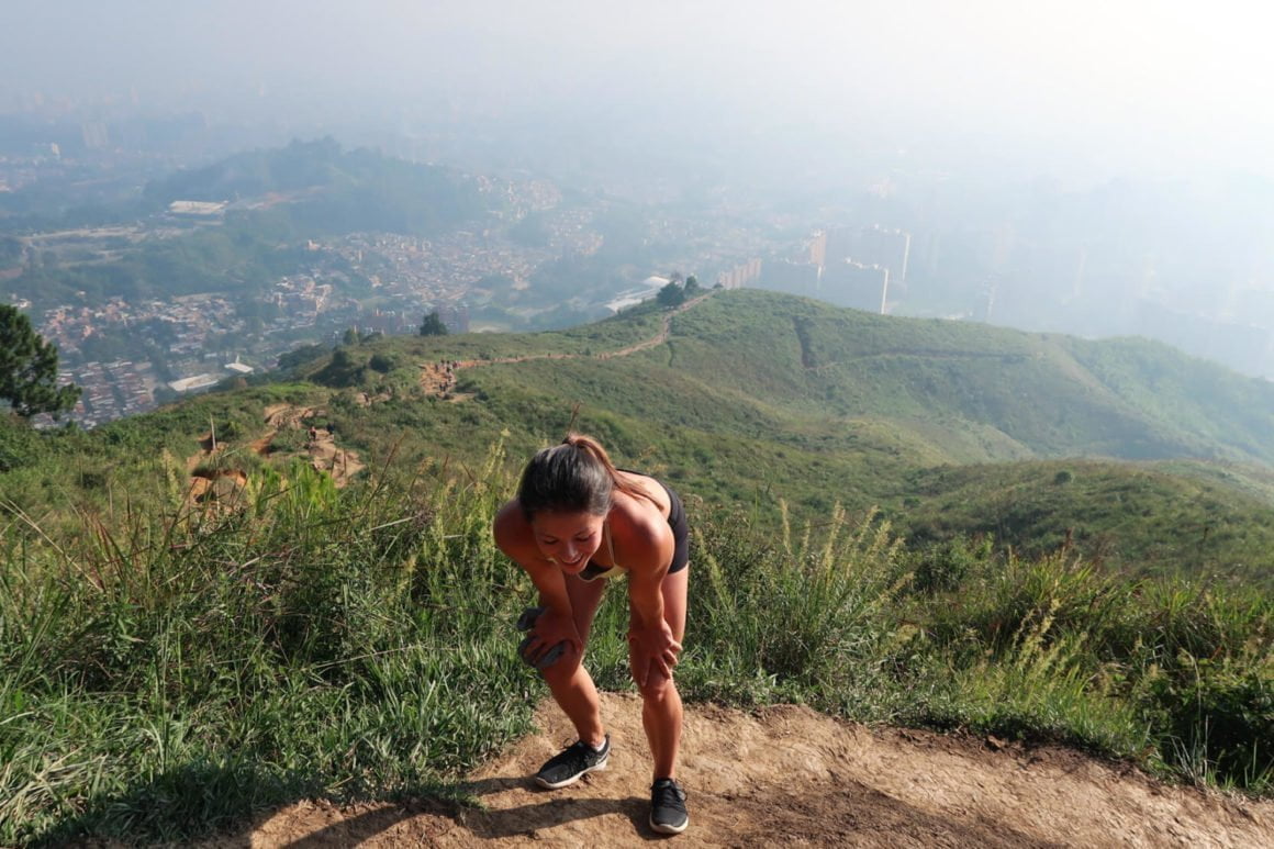
Why It's Special
Views, fresh(-er) air, a unique hilltop workout area, and the opportunity to join in and observe Medellín's workout culture.
Overview
The short-but intense Cerro de las Tres Cruces hike is a must-do for any fitness-minded person in Medellin.
With great views, interesting people watching, convenient juice and fruit vendors, and an awesome mountaintop outdoor gym, the only wonder is why more foreigners don't join the legions of Paisas who do it.
Quick Info
- Getting There: Best by taxi unless you live in Belén. It's about 12,000 COP from El Poblado.
- Duration: 20-40 minutes up
- Difficulty: Moderate. Hikers of all levels will be able to manage.
- Distance: 1.2 kilometers each way
- Elevation Gain: 320 meters / 1000 feet
2. Cuevas del Higueron
A "Cave" and Waterfall Hike by Parque El Salado

Why It's Special
The "caves" aren't special at all, but the waterfall's nice and there's a cool spot for having fresh-caught trout at the bottom of the hike.
Overview
With caves, a waterfall, an ancient trail, and easy access from Medellin (even by public transit), the Cuevas del Higueron hike would seem like a can't miss.
Well it's not.
It's worth doing… but it has its ups and downs, literally and figuratively. The "caves" and the beginning of the hike are a letdown, but the waterfall and restaurant at the end are worth it.
Quick Info
- Getting There: 10,000 COP taxi ride (10-15 mins) or a 2,100 COP bus ride from Envigado.
- Duration: 3-4 hours to go up to the Cuevas del Higueron and the waterfalls and back down again
- Difficulty: Moderate. There is no technically challenging trail. It's just up and down hill.
- Distance: Approximately 7 km / 4.5 miles
- Elevation: Approx 500 meters / 1600 feet gain from trailhead to waterfalls.
3. Arenales Waterfall Hike
Two Waterfalls, One Viewpoint, and One Prison

Why It's Special
A couple lush, tropical waterfalls, an amazing view, and perspective on a bit of Medellin's Pablo Escobar history.
Overview
This is probably the best known of all Medellin hiking trails (particularly the bottom half).
Starting up in the mountains at what remains of Pablo Escobar's infamous "prison," La Catedral, this one-way hike takes you down first through steep pine forest, then into dense jungle, and on to two different waterfalls, Salto del Angel and Chorro de la Campana. At the end of the hike, you emerge from the forest at Arenales, where you can enjoy a fantastic north-facing view of the entire city of Medellin while you wait for a bus back to town.
Warning: Be prepared to get your feet wet, because a good chunk of this hike goes not along, but on, a stream.
Quick Info
- Getting There: 25,000 COP taxi from the city (25 minutes from Envigado). 2,100 COP bus back down
- Duration: 1.5-2 hours. We took two hours with quite a bit of lallygagging. If you go fast you could do it in an hour and a half.
- Difficulty: Medium hard. The distance is not difficult, and it’s almost all downhill. The challenge is climbing down a few very steep slopes, walking through rivers, and jumping from rock to rock.
- Elevation: 300 meters downhill. This is a one-way hike.
4. Parque Arvi via Cerro Pan de Azucar
A Backdoor to Two of Medellin's Top Tourist Attractions

Why It's Special
The best of all views of Medellin from Cerro Pan de Azucar, and un-touristy way to get to a top Medellin attraction, an excellent belly and body-warming menu del dia up top and a memorable Metrocable gondola ride back down.
Overview
We recommend this hike to all of our friends, and friends' friends, who visit Medellin.
It's an unforgettable, but virtually unknown, alternative route to Medellín's top tourist attractions, Parque Arví and the Metrocable. You'll enjoy the best views of the city from Cerro Pan de Azucar, a glimpse of Medellin's rural roots, and great food at the end.
Quick Info
- Getting There: Best by taxi or Uber. There are also regular public buses leaving from Prado metro station.
- Duration: 3-4 hours plus whatever time you spend eating and hanging out in Parque Arví.
- Difficulty: Moderate. The only challenge for some may be the overall distance and elevation gain.
- Distance: 9 km / 5.6 mi (It's a one-way hike.)
- Distance from Medellin: The trailhead is a 30 min taxi or 50 min bus from the center of Medellín.
- Elevation: 675 m / 2,200 ft net (800 m / 2600 ft u<p, 124 m / 400 ft down)
5. El Hato Waterfalls to San Felix Paragliding Launch
Hike Up, Fly Down
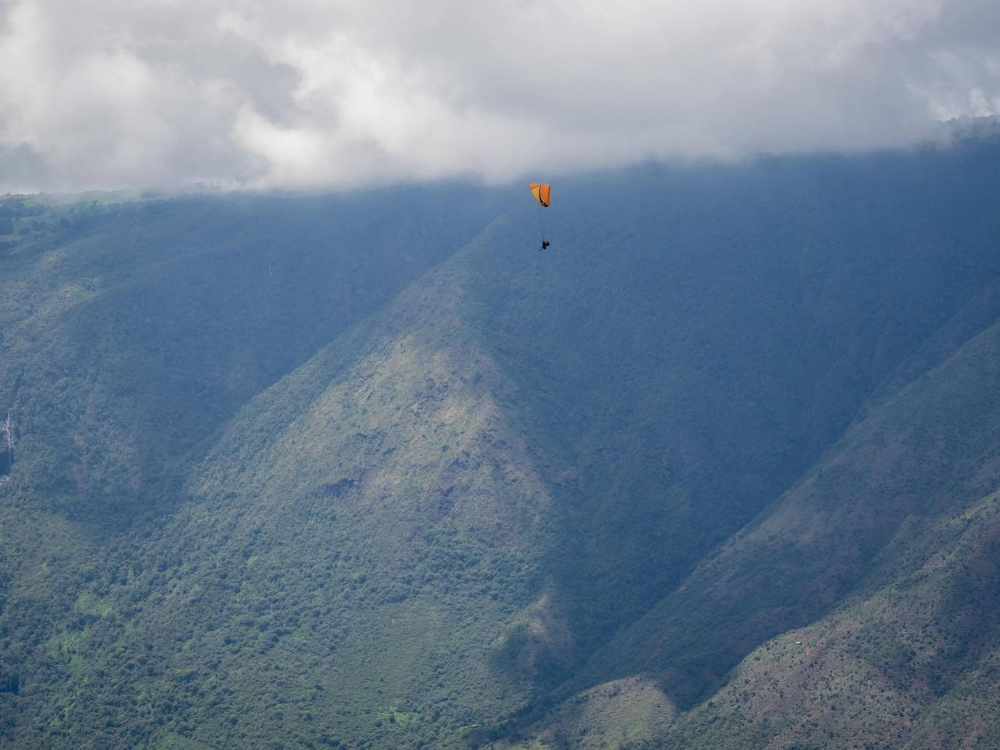
Why It's Special
The walk through the Bello neighborhood, the El Hato waterfalls, and the possibility to paraglide afterwards make up for an unexceptional trail. Also, if you've never paraglided before, this is the place to try. It's better than you think.
Overview
If you've ever hiked to the top of a mountain and wished you could fly down instead of hike, this is a dream come true.
Starting from Medellin's Bello neighborhood, you hike up past Chorro El Hato waterfalls until getting to San Felix and the paragliding launch point. Then you descend like a superhero.
Quick Info
- Getting There: Metro to Bello station, from where you can either walk or take a bus to the trailhead
- Duration: 2.5 hours to San Felix from the trailhead, plus time for stops at the waterfall. Add an extra hour if you hike from the Bello metro station.
- Difficulty: Moderately difficult. It’s steep. And it's slippery when wet.
- Distance: 4.9 km from the trailhead to the paragliding area. An extra 4 km to walk from Bello metro station to the trailhead.
- Distance from Medellin: Bello metro station is about 20 minutes from central Medellin.
- Elevation: 662 m net (880 m climbing, 188 m descent)
6. Cerro Quitasol
From Metro Station to Mountaintop

Why It's Special
The views all the way up make it hard to focus on the path. On the way down, the pre-Hispanic trail and ruins and the refreshing swimming area towards the bottom are a nice reward.
Overview
Starting right from the northernmost Medellin metro station, this hike goes up, up, and up. Straight up!
It's a strenuous climb, but worth it for the crazy views from the top and the sense of accomplishment of having climbed a mountain.
Better yet, the way down isn't so steep, is mostly shaded from the sun, and has a refreshing swimming hole. And the neighborhood nearby the metro station is a great place for a celebratory beer or meal.
Quick Info
- Getting There: Hike starts and ends at Medellín's Niquía metro station.
- Duration: From the metro station and back again, including breaks to swim and get refreshments at the bottom, it took us 7 hours. A hard-core friend who hustled up and down, jogging at times, did it in 5 hours.
- Difficulty: High. The trail is steep and unrelenting. If you’re not in the greatest shape, it’s still worth it to do even just half the hike. Many groups we passed by did so.
- Distance: 11 km, but count on more for getting “lost” from time to time and taking not the most direct route
- Elevation: Up and down. Approx 1200 meters total elevation gain.
7. Cerro Tusa
The World's Largest Natural Pyramid

Why It's Special
Cerro Tusa, the world's tallest natural pyramid, truly is a sight to behold and to say you've hiked to the top makes it that much more memorable. You won't forget the crazy steep scramble up, and slide down, either.
Overview
Cerro Tusa doesn't look like it's real. It looks like a 3-year-old drew it.
But there's no way a 3-year-old could hike it.
The Cerro Tusa hike is not really a hike. It's a crawl-your-way-up-and-don't-look-down. It's super steep, but it's also short. And, depending on who you ask, it's fun.
Most people do the hike as a day trip from Medellín because it's only a couple of hours away, but if you have time we'd recommend spending some time in the old-school, friendly town of Venecia.
Quick Info
- Getting There: 1.5 hours by car or 2.5 hours by bus plus taxi. 15 minutes from Venecia.
- Duration: 1.5-3 hours up and 1.5-2 hours down. Depends significantly on fitness and confidence levels
- Difficulty: Dangerously difficult
- Distance: 5 km / 3 miles
- Elevation: 500 meters / 1600 feet
The Unbelievable, Otherworldly Trek
The Paramo del Sol
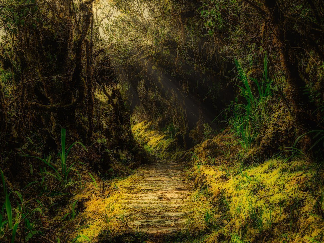
Why It's Special
You'll experience multiple landscapes, sunsets, sun- and moonrises, and natural environments that you'll never find anywhere else in the world.
Overview
We saved the best for last.
The only thing is this hike is not in Medellin.
It's four to five hours from Medellin near a town called Urrao. But if you're looking for an unforgettable and one-of-a-kind outdoor adventure, it's worth taking the time to go to.
It's called the Paramo del Sol. It's a two- or three-day trek that includes drop-your-jaw-and-forget-to-take-pictures-while-reconsidering-your-place-in-this-world sunsets and moonrises, a hummingbird beehive, a fairy-tale-worthy moss jungle, hundreds of unique orchids, views of seemingly all of Colombia, and high-on-mushrooms-like paramo scenery.
We can’t recommend trekking in the Paramo more highly.
Quick Info
- Getting There: Bus or drive to Urrao, then chiva or taxi to the trailhead.
- Duration: Minimum 7 hours from the base to the top. 11 hours or more if you take the less-direct route up and stop along the way, which we recommend.
- Difficulty: Medium-difficult. While our group moaned and groaned about sore legs the day after the trek, we made it up and down with minimal complaint.
- Distance: 14 kilometers on the direct route. But if you take the less direct route and make many swamp-avoiding detours like us, then expect to cover about 42 kilometers (a marathon!) over two days.
- Distance from Medellin: 4 hours by car. 5 hours by bus.
- Elevation: 1,700 m net gain from 2,380 m above sea level at the base to 4,080 m at the top of Alto Campanas.
How to Put Together a Magnificent Medellin Trip
For all the ingredients you need to put together a magnificent Medellin trip—where to stay, what to do, what to eat, where else to visit in Colombia—see our Medellin Travel Manual.
And if you have any questions, comments, or suggestions to share with other readers, please share them in the comments!
Literally everything in this article is wrong. Whoever wrote this has no idea what they’re talking about please disregard everything on this page
We're sorry if you had a hard time with one of the hikes, but we do our best to be accurate and detailed with these guides. We did each of the hikes listed and mapped them out and timed them using GPS, so they're as accurate as possible.
Hey Chris,
Thanks for the guide! Maybe you could have been more detailed, but you certainly were never wrong. Thank god we had your guide for all of the important waypoints!
Thanks again,
Moose
Thanks for backing us up, Moose! Not only do I really appreciate the comment, but I really like your nickname. It's fun to think there's a Moose on the loose in the Colombian hills!
We have done four of these, and have read descriptions here first. Seems pretty spot on to us. Thanks for posting these. Please disregard Casey… Feedback is very not specific.
Thanks for sticking up for us, Kurt! And we're really happy to hear our posts have helped you enjoy some of the hikes we did.
Why did you say that ?. I am from Medellín and all that they say is true.
Hi, I just wanted to thank you so much. Yesterday my boyfriend and myself did the Cerra Quitasol hike that you described. Great directions and just enough description. It was our last day so we wanted to get out on a high and it fit the bill. Superb hike. We tried to find a decent hike through local tour companies. You succeeded where they failed.
Thank you so much. Sophie and Steve xx
This warms our heart as much as our faces got burnt when we hiked up Cerro Quitasol ourselves! Thanks for making our day (or at least our morning) Sophie and Steve!
During our trip to Medellin we wanted to do many of these hikes but my partner and I are not very experienced hikers. We like to do about 2 to 3 mile trails that are very easy to not get lost. We understand that these hikes may not seem like "hikes" for more advanced hiking enthusiasts.
During our time in Medellin, we really enjoyed "hiking" Cerro El Volador Natural Park. Sure it is more of a park than a hike but it provided great views of the city, had lots of local vibes, and gave us our hiking fix. Best of all, there are many food vendors at top that sell local food and drinks. One of the vendors sold fresh Guarapo where they pressed the sugar cane right in front of you. It was life changing.
Thanks for pointing out Cerro Volador, Dave. Good find. It's worth adding that in addition to the vendors there are pretty much 360 degree city views from up top and a workout area. It's best to go on Sunday mornings when it's ciclovia and it's teeming with cyclists and pedestrians—and no cars.
As we wrote in our overrated/underrated Medellin attractions post go to Volador instead of Pueblito Paisa.
Thanks again for the shoutout to Kinkaju Hikes ! A couple participants have said they have found us though “an awesome blog” they came across- I’m sure it was you guys. Keep up the good work ! -Jack
We're glad to have inspired people get out there and enjoy the fantastic hiking around Medellin and glad you're there to make it easier for them. All the best, Jack!
Hey guys,
Thanks for the information! It's hard to find your trails on Wikiloc, do you have any advice for this? I can't see any way to search for a username or anything (what is your username by the way?). Is there any other way to get hold of the GPX maps so I can follow them on another app?
Andy
Hey Andy, Here are the trails we've shared on Wikiloc: https://www.wikiloc.com/wikiloc/user.do?id=3675097. Keep in mind you need to pay for the app to be able to follow them and that the trails aren't always 100% since we made them with our phones, so if the signal cut out for whatever reason it just makes a straight line between the two points with gap in the signal. Enjoy!
Hey Chris! this list is great but…
"There’s only one problem:
The trails are not well-known, well-marked, or well-covered online."
Unfortunately you didn't solve the original problem you stated because you didn't tell us how to actually arrive and start each hike in detail 🙁 can you add this info? Or email me? i'd love to do more of these 🙂
Thanks!
Ha, fair enough, Robin. We did our best to describe the routes. I highly recommend you get Wikiloc. You can find a lot more hikes around Medellin on there marked on GPS.
I found this page while looking for short hikes to do while in Medellin and a way to meet others who live here. Some of them are a little too extreme for me at the moment, but I look forward to getting in shape for them. They look amazing. Thanks for your effort.
AllTrails is another good app for hikes